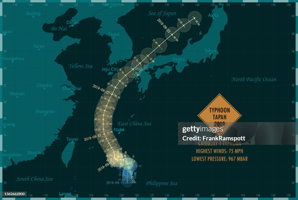
Typhon Tapah 2019 Suivi de la mer de Chine orientale Infographie - Illustrations
Typhoon Tapah 2019 Track East China Sea Infographic. Map projection: World Miller Cylindrical. All source data is in the public domain. NOAA's International Best Track Archive for Climate Stewardship (IBTrACS) data. Countries and Boundaries: Made with Natural Earth.

Obtenez cette image dans différents formats et cadres disponibles sur Photos.com.
ACHETER UNE LICENCE
Toutes les licences libres de droits comprennent des droits d'utilisation mondiaux, une protection complète et une tarification simple avec des réductions pour les achats importants.
385,00 €
EUR
Getty ImagesTyphon Tapah 2019 Suivi De La Mer De Chine Orientale Infographie, Photo Téléchargez des illustrations Typhon Tapah 2019 Suivi de la mer de Chine orientale Infographie premium authentiques avec Getty Images. Découvrez des illustrations haute résolution similaires dans notre vaste catalogue visuel.Product #:1362662800
 Téléchargez des illustrations Typhon Tapah 2019 Suivi de la mer de Chine orientale Infographie premium authentiques avec Getty Images. Découvrez des illustrations haute résolution similaires dans notre vaste catalogue visuel.Product #:1362662800
385€50€
Getty Images
In stockINFORMATIONS
Crédits :
Créatif - n° :
1362662800
Type de licence :
Collection :
DigitalVision Vectors
Taille max. de fichier :
4997 x 3358 px (42,31 x 28,43 cm) - 300 dpi - 4 MB
Date de chargement :
Lieu :
Japan
Infos autorisations :
Aucune autorisation n'est nécessaire
Catégories :
- 2019,
- Accident et désastre,
- Carte,
- Cartographie,
- Catastrophe naturelle,
- Cercle,
- Changement climatique,
- Création numérique,
- Danger,
- Date écrite,
- Donnée,
- Environnement,
- Frontière,
- Graphisme d'information,
- Géographie physique,
- Horizontal,
- Illustration,
- Image composite numérique,
- Image en couleur,
- Infographie - Production artistique,
- Japon,
- Menace,
- Mer,
- Mer de Chine Orientale,
- Mer des Philippines,
- Mer du Japon ou Mer de l'Est,
- Message écrit et lettre de l'alphabet,
- Météorologie,
- Océan Pacifique,
- Océan Pacifique nord,
- Panneau avertisseur,
- Phénomène climatique extrême,
- Préfecture de Fukuoka,
- Questions sociales,
- Sans personnage,
- Temps qu'il fait,
- Temps qui passe,
- Tempête tropicale,
- Trace,
- Typhon,
- Vectoriel,
- Vent,
- Ville - Milieu urbain,
- Ville de Fukuoka,